
1Department of Preparatory, Peter the Great Polytechnic University, China.
2Changning County High School, Yibin City, China.
3Anhui Jingxian High School, Xuancheng, China.
*Corresponding author: Wei Tao Shen,
Department of Preparatory, Peter the Great Polytechnic
University, 195251, China.
Email: 1504329343qq.com
Received: Oct 21, 2025
Accepted: Nov 12, 2025
Published Online: Nov 19, 2025
Journal: Journal of Artificial Intelligence & Robotics
Copyright: © Shen WT (2025). This Article is distributed under the terms of Creative Commons Attribution 4.0 International License.
Citation: Shen WT, Chen ST, Yuan J, Huang W. Innovation and practical application of artificial intelligence technology in water conservancy engineering. J Artif Intell Robot. 2025; 2(2): 1032.
Amidst the current wave of artificial intelligence and the accelerated implementation of the smart water conservancy strategy, water conservancy projects face challenges such as massive data volumes, complex operating environments, and diversified scheduling demands. Traditional methods increasingly show limitations in terms of timeliness, accuracy, and intelligence. The integration of artificial intelligence presents new opportunities for the intelligent and digital transformation of water conservancy engineering. This paper focuses on the innovations and practical applications of artificial intelligence in water conservancy projects, systematically elaborating on the use of machine learning, deep learning, and explainable artificial intelligence in hydrological forecasting, engineering monitoring, and water resources optimization. Furthermore, it explores innovative models integrating artificial intelligence with water conservancy, including basin management empowered by digital twins, real-time monitoring driven by edge computing, and secure data sharing enabled by federated learning. The aim is to demonstrate that artificial intelligence can effectively enhance scientific decision-making and operational efficiency in water conservancy projects, thereby providing solid technical support and sound decision-making foundations for building a smart water conservancy system and promoting the sustainable utilization of water resources.
Keywords: Artificial intelligence; Water conservancy project; Machine learning; Deep learning; Intelligent scheduling.
As a vital component of social infrastructure, water conservancy projects play an irreplaceable role in flood control and disaster mitigation, water supply security, ecological conservation, and socioeconomic development [1]. However, with the intensification of global climate change and the continuous expansion of human activities, water resource systems face unprecedented challenges. On one hand, extreme weather events occur frequently, and flood disasters and drought problems are becoming increasingly severe [2]. On the other hand, population growth and accelerated urbanization have intensified the imbalance between water supply and demand. Concurrently, water ecological degradation, water pollution, and heightened ecosystem vulnerability have imposed stricter requirements on the operation and management of water conservancy projects. Against this backdrop, achieving intelligent, scientific, and sustainable management of water conservancy projects has become a focal point for both academia and the engineering community [3].
Traditional water conservancy management methods primarily rely on physical mechanism models and human experience [4]. While these approaches can partially explain hydrological processes and guide scheduling decisions, they often exhibit limitations such as insufficient accuracy, poor real-time performance, and limited adaptability when confronting complex nonlinear relationships, multi-source heterogeneous data, and dynamic uncertain environments. For instance, empirical formula-based hydrological forecasting models exhibit significant prediction errors under extreme rainfall conditions. Rule-based reservoir operation methods struggle to balance multiple objectives such as flood control, water supply, and ecological conservation. Manual inspection methods prove inefficient in dam safety monitoring, making it difficult to promptly identify potential risks. These shortcomings urgently require new technological approaches to address.
The rapid advancement of Artificial Intelligence (AI) presents new opportunities for the transformation and upgrading of water conservancy projects [5]. As a technology capable of automatically learning patterns from massive datasets to enable prediction and decision-making, AI demonstrates unique advantages in pattern recognition, time series forecasting, optimized scheduling, and intelligent monitoring. In recent years, deep learning has achieved significant results in rainfall-runoff forecasting and flood prediction; reinforcement learning has demonstrated strong adaptability in reservoir cluster joint scheduling and water resource optimization; The integration of computer vision and drone technology has provided efficient means for dam safety monitoring and disaster emergency response; emerging methods such as federated learning and causal inference offer new approaches to cross-regional data collaboration and model interpretability. These advancements demonstrate that AI not only enhances the operational efficiency and management level of water conservancy projects but also propels the industry toward intelligent and sustainable development [6].
Nevertheless, AI applications in water conservancy remain exploratory, facing several unresolved challenges. First, water data exhibits multi-source heterogeneity, uneven spatiotemporal distribution, and scarcity of extreme event samples, complicating model training and generalization. Second, the “black-box” nature of deep learning methods limits their use in engineering decision-making due to transparency and interpretability gaps. Third, AI systems exhibit low integration with existing water management frameworks, lacking unified standards and protocols. Furthermore, barriers to cross-departmental and cross-regional data sharing and collaborative governance constrain AI’s application in large-scale watershed management.
Against this backdrop, this study aims to systematically investigate AI applications and development models in water resources engineering. Key contributions include: First, proposing a hydrological forecasting and flood control method integrating deep learning with causal inference to enhance prediction accuracy and decision-making rigor. Second, establishing an engineering monitoring and risk early-warning system based on UAVs and edge computing for real-time monitoring and rapid response. Third, it explores the application of federated learning in water resource optimization to address cross-regional data sharing and privacy protection challenges. Finally, integrating digital twin concepts, it proposes an intelligent management model for water ecological environment protection, providing technical support for ecological restoration and sustainable development.
Related work
In recent years, the application of artificial intelligence in water conservancy projects has deepened, emerging as another research hotspot. Given existing research limitations, this work primarily focuses on the following aspects.
Hydrological forecasting and flood control:
Traditional hydrological forecasting primarily relies on physical mechanism models, which effectively explain hydrological processes but exhibit limited prediction accuracy under extreme climatic conditions. With the continuous development of deep learning, time series models such as LSTM and FRU have been widely applied to rainfall-runoff prediction, significantly improving the accuracy of flood peak forecasting. Furthermore, reinforcement learning methods have been introduced into the joint scheduling of reservoir clusters. By constructing an agent-environment interaction model, they provide multi-objective optimization for flood control, water supply, and ecological protection [7].
Engineering inspection and risk early warning:
Water conservancy projects typically have extended operational lifecycles and complex structures, making reliable engineering inspections crucial for ensuring stable operation. Traditional manual inspection methods are inefficient and struggle to identify potential risks. With the continuous advancement of computer vision and image recognition techniques, this technology has been widely applied in engineering inspection and risk early warning. The integration of drones and AI for image analysis enables rapid acquisition of large-scale inspection data during disaster response, significantly enhancing the efficiency of risk early warning [8].
Water resource optimization:
Optimizing water resource allocation is a crucial approach to resolving supply-demand conflicts. Traditional methods often employ optimization models such as linear programming and dynamic programming, but these frequently struggle to find optimal solutions in multi-objective, multi-constraint environments. In recent years, machine learning and reinforcement learning have been extensively applied to water resource allocation problems. Random forest-based prediction models enable precise forecasting of agricultural water demand, while reinforcement learning continuously optimizes scheduling strategies in multi-source environments, achieving synergistic development of water supply efficiency and ecological conservation [9].
Water ecological environment protection:
Water ecological environment protection is a vital component of sustainable water resources management. Traditional water quality monitoring relies on manual sampling and laboratory testing, which suffer from low efficiency and poor real-time capabilities. AI, combined with sensor networks and IoT technology, enables real-time monitoring and intelligent analysis of key water quality indicators. Deep learning models are applied to water quality prediction and algal bloom risk early warning, capable of issuing alerts days in advance. In pollution control, large AI models can rapidly identify pollution sources and optimize wastewater treatment plant operating parameters, achieving dual goals of energy conservation and emission reduction while ensuring water quality compliance [10].
This study proposes an intelligent scheduling and risk warning method for water conservancy projects that integrates Deep Reinforcement Learning (DRL), Causal Inference, and Federated Learning [11]. This approach addresses challenges in traditional water engineering management, including insufficient prediction accuracy, poor model interpretability, and difficulties in cross-regional data collaboration. The overall framework comprises six components: data preprocessing, state modeling, reward function design, reinforcement learning optimization, causal inference refinement, and federated learning collaboration.
Data preprocessing and feature engineering
Prior to model training, multi-source hydrometeorological data undergoes preprocessing. The raw dataset is expressed as shown in Equation 2-1:
Here, Xt represents input features at time t, such as precipitation, temperature, and water level, while Yt denotes corresponding output variables like runoff volume or scheduling outcomes.
To eliminate the influence of different dimensions and enhance model convergence speed, a normalization method is applied to each feature. This is expressed in Equation 2-2:
where μ and σ denote the sample mean and standard deviation, respectively. This process ensures features fall within a unified numerical range, promoting gradient stability and rapid model convergence.
Subsequently, a sliding window mechanism is employed to transform the time series data into supervised samples, as expressed in Equation 2-3.
Here, k denotes the window length, capturing the system’s temporal dependencies and short-term dynamic characteristics. This approach formalizes the time series prediction task as an input-output mapping problem, enabling the model to learn the nonlinear evolution patterns of hydrological responses within high-dimensional temporal spaces.
State and action space modeling
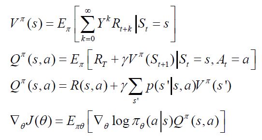
To develop a deep reinforcement learning-based intelligent scheduling model for water conservancy projects, this study abstracts the watershed system as a Markov Decision Process (MDP). Within this framework, the system’s operational state at time step t is represented by state variable St. The agent selects action at based on the current state, transitions to the next state St+1 under environmental influence, and receives corresponding reward feedback. This modeling process forms the decision foundation of reinforcement learning.
The state space is defined as shown in Equations 2-4.
Here, Qt denotes reservoir storage capacity, describing the current water storage level. Rt represents inflow, reflecting external water processes and meteorological inputs. Et represents ecological indicators, measuring the health status of the watershed ecosystem, such as ecological flow or dissolved oxygen concentration. This triad-based state space comprehensively characterizes the hydrological, engineering, and ecological features of the watershed, providing the agent with sufficient environmental perception information. Through the design of the state space, the model can simultaneously consider flood control safety, water supply benefits, and ecological constraints, achieving a multi-objective dynamic equilibrium.
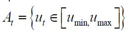
The action space defines the set of scheduling decisions an agent can execute at time step t. Its value range is constrained and managed by engineers, ensuring the model adheres to practical engineering feasibility during learning. Its expression is shown in Equation 2-5.
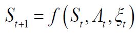
The state transition function describes the dynamic rules governing the system’s evolution from the current state to the next time step after executing an action. Given the high nonlinearity and uncertainty inherent in real hydrological systems, this study employs a data-driven deep reinforcement learning approach. Through interactive training, it approximates the solution to achieve dynamic characterization and strategy optimization for complex systems. Its expression is shown in Equation 2-6.
Reward function design
To guide the deep reinforcement learning agent toward multi-objective optimal decision-making in complex water management scenarios, this study constructs a multi-objective reward function integrating water supply benefits, flood risk, and ecological costs. This function comprehensively reflects the system’s economic efficiency, safety, and sustainability, serving as the key basis for the agent’s policy updates. Its expression is shown in Equation 2-7.
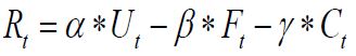
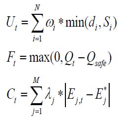
Rt denotes the instantaneous reward value at time t. α, β, and γ represent the weighting coefficients for water supply benefits, flood risk, and ecological costs, respectively, balancing the importance of these three objectives. The expressions for the water supply benefit function, flood risk function, and ecological cost function are as follows.
Reinforcement learning optimization
After defining the state space, action space, and multi-objective reward function, this study employs a Deep Reinforcement Learning (DRL) framework based on policy gradients to achieve dynamic optimization of water management system scheduling strategies. The agent continuously updates its policy through interaction with the environment to maximize long-term cumulative rewards. The core principle of reinforcement learning is to progressively approximate optimal strategies by evaluating the returns generated by different actions under various states. The value function definition, action value function definition, Bellman equation, and policy gradient update formula are expressed as follows.
Hydrological forecasting and flood control
Hydrological forecasting and flood control scheduling form the core of modern water resources management. Their accuracy and efficiency directly impact flood safety, water supply security, and the stable operation of regional socio-economic systems. Against the backdrop of intensifying global climate change, frequent extreme rainfall events and ongoing changes in basin surface conditions have exposed limitations in traditional hydrological models—based on physical mechanisms or empirical formulas—when addressing highly nonlinear, time-varying processes and integrating multi-source heterogeneous data. These models increasingly reveal issues such as limited prediction accuracy, insufficient real-time responsiveness, and weak generalization adaptability. Against this backdrop, Artificial Intelligence (AI) technologies—with their robust capabilities in nonlinear fitting, time-series modeling, and adaptive optimization—offer a novel technical pathway to enhance the intelligence of hydrological forecasting and operational decision-making [12].
In hydrological forecasting, AI methods represented by deep learning demonstrate significant advantages. Recurrent neural network structures such as Long Short-Term Memory (LSTM) and Gated Recurrent Units (GRU) effectively capture long-range dependencies and dynamic lag effects within rainfall-runoff sequences, substantially improving the accuracy of peak discharge and peak timing forecasts. Convolutional Neural Networks (CNNs) and their derivative models excel at extracting key features from multi-source spatial data, including remote sensing imagery, radar-derived precipitation, and digital elevation models. This supports the identification of spatial precipitation distributions within basins and the modeling of spatial heterogeneity in runoff formation. Compared to traditional hydrological models, deep learning models possess inherent advantages in handling high-dimensional, unstructured, and massive datasets, demonstrating greater robustness in simulating extreme hydrological events [13]. Notably, the emerging physics-driven and data-driven hybrid modeling paradigm has gained traction in recent years. By embedding physical constraints such as hydrodynamic equations and energy conservation laws into neural network structures, or incorporating physical residual terms into loss functions, this approach effectively enhances model generalization and process consistency. This shift propels hydrological forecasting from purely black-box methodologies toward interpretable, physically meaningful approaches.
In flood control operations, reinforcement learning offers innovative solutions for multi-objective coordinated scheduling in complex reservoir systems. By framing the scheduling process In flood control operations, reinforcement learning offers innovative solutions for multi-objective coordinated scheduling in complex reservoir systems. By framing the scheduling process as a sequential decision problem and leveraging agent-environment interaction mechanisms, reinforcement learning autonomously learns scheduling strategies approximating global optima through trial-and-error with reward feedback. This enables dynamic trade-offs among multiple objectives including flood control, water supply security, ecological flow maintenance, and power generation benefits [14]. For instance, scheduling agents built using deep Q-networks or proximal policy optimization algorithms can dynamically generate flood discharge plans and gate control strategies based on real-time hydrological conditions, weather forecasts, and basin status information. This significantly enhances the system’s ability to respond to sudden floods and improves overall scheduling efficiency. Compared to traditional scheduling models based on static rules or linear programming, reinforcement learning methods exhibit superior environmental adaptability and decision flexibility, making them more suitable for highly uncertain scheduling scenarios.
Although artificial intelligence technologies demonstrate broad application prospects in hydrological forecasting and flood control scheduling, their further development faces several critical challenges. First, the scarcity of extreme flood event samples leads to insufficient model training, limiting their generalization capabilities in rare scenarios. Second, the inherent black-box nature of deep learning models weakens the interpretability of their decision-making processes, affecting credibility and adoption willingness in engineering practice. Additionally, existing large AI models exhibit low integration with industry standards, operational protocols, and business systems, failing to establish a standardized, scalable engineering application framework. Given current research limitations, breakthroughs should focus on the following directions: introducing explainable AI technologies to enhance model transparency through feature attribution and attention visualization. Construct a digital twin-based watershed simulation platform to achieve closed-loop verification across the entire forecasting-dispatching-decision-making process. Explore cross-institutional and cross-basin federated learning mechanisms to promote sample sharing and collaborative modeling while safeguarding data privacy. Through these approaches, it is anticipated that hydrological forecasting and flood control systems will gradually evolve toward a new phase characterized by intelligent driving, scientific transparency, and operational integration.
Engineering monitoring and risk early warning
As vital components of social infrastructure, the operational safety of water conservancy projects directly impacts public safety and regional stability. However, structures like reservoirs, dams, and levees—with their complex designs and extended operational lifespans—remain susceptible to environmental changes and aging, harboring potential risks such as seepage, deformation, and piping. Traditional monitoring methods primarily rely on manual inspections or single-point sensors, suffering from poor real-time performance, limited coverage, and weak data processing capabilities. These approaches struggle to meet the demands of modern water conservancy projects for efficient, precise, and intelligent monitoring. With the continuous advancement of artificial intelligence technology, its application in engineering monitoring and risk early warning is increasingly demonstrating significant advantages.
In engineering monitoring, artificial intelligence enables automatic identification and real-time alerts for structural anomalies through computer vision and machine learning technologies. For instance, image recognition models based on Convolutional Neural Networks (CNN) and object detection algorithms like the YOLO series can automatically identify abnormal features such as surface cracks and seepage in dams, achieving recognition accuracy exceeding 90%. This significantly surpasses the efficiency and accuracy of manual inspections. Simultaneously, sensor networks integrated with AI anomaly detection algorithms enable real-time monitoring and trend analysis of critical parameters like stress, seepage pressure, and displacement, allowing early identification of potential risks [15]. Moreover, drones equipped with high-resolution cameras and AI image recognition systems can swiftly complete large-scale engineering inspections. For instance, in disaster response scenarios, the integration of drones and AI enables rapid surveying of approximately 50 square kilometers of disaster-affected areas within 30 minutes, providing efficient support for emergency dispatch.
Regarding risk early warning, artificial intelligence enhances prediction accuracy and response speed through time series modeling and multi-source data fusion. Anomaly prediction systems based on models like LSTM and Autoencoder can identify nonlinear trends in hydraulic engineering operations and issue early warning signals. Simultaneously, AI integrates video surveillance, sensor data, and remote sensing imagery to construct comprehensive risk assessment models, enabling rapid responses to sudden disasters like floods, landslides, and debris flows. In select digital twin water conservancy pilot projects, AI models have achieved real-time simulation of flood processes, improving forecast accuracy by 15-20% and reducing warning response times to the 10-minute range, significantly enhancing engineering disaster prevention and mitigation capabilities. Despite AI’s immense potential in engineering monitoring and risk warning, challenges persist, including data gaps, insufficient model robustness, and difficulties in system integration. Future development directions include: constructing digital twin engineering systems to enable virtual monitoring and simulation-based early warning; promoting cross-departmental data sharing and standardization; and introducing federated learning and explainable AI to enhance system security and transparency. These efforts will provide robust technical support for the intelligent operation and risk prevention of water conservancy projects. A comparison between traditional and AI-based methods in engineering inspection and risk early warning is shown in (Table 1).
| Indicator/Dimension | Traditional methods | AI method |
|---|---|---|
| Monitoring coverage | Relies on manual inspections or single-point sensors, resulting in limited coverage | Video recognition, drone inspections, sensor networks, and AI enable large-scale real-time monitoring |
| Monitoring accuracy | Manual identification of cracks and leaks is highly subjective and prone to significant errors | Deep learning models automatically detect cracks and leaks with accuracy exceeding 90% |
| Early warning response time | Traditional flash flood warnings typically require 1–2 hours | AI-powered small watershed warning models reduce response time to 10 minutes |
| Data processing capacity | Reliance on manual aggregation makes real-time processing of massive datasets challenging | AI integrates remote sensing, video, and sensor data for real-time analysis |
| Disaster response efficiency | Manual inspections are time-consuming, and post-disaster information acquisition is slow | Drones and AI can survey 50 km² disaster areas within 30 minutes |
| Economic and safety benefits | Low investment but limited efficiency with higher risks | High initial investment, but costs recoverable within 3 to 5 years, reducing disaster losses by 10% to 15% |
Optimizing water resource allocation
With population growth, urban expansion, and the impacts of climate change, conflicts between water supply and demand are increasingly prominent. Optimizing water resource allocation has become a core challenge in water engineering management. Traditional water resource scheduling and supply plans are often based on static planning and empirical rules, making them ill-suited to adapt to dynamic changes in water demand and the complex structure of watershed systems. The application of artificial intelligence technologies offers smarter and more flexible approaches to water resource management, demonstrating significant advantages particularly in cross-regional water transfers, agricultural irrigation management, and urban water supply scheduling.
In inter-basin water transfers and agricultural irrigation, AI leverages machine learning models to analyze historical water usage records, meteorological data, and crop water requirements, enabling accurate forecasting of future water demands. For instance, algorithms like decision trees or support vector machines can identify and estimate agricultural water requirements across different regions, providing a basis for water diversion routes and irrigation plans. Simultaneously, reinforcement learning methods can continuously optimize water transfer schemes in scenarios involving multiple water sources and obobjectives, enhancing water resource utilization efficiency while balancing ecological conservation goals.
Within urban water supply systems, AI facilitates the establishment of intelligent dispatch platforms that monitor the operational status of water treatment plants, reservoirs, and pipeline networks in real time, enabling dynamic resource allocation. By analyzing residential water consumption patterns, industrial usage fluctuations, and weather trends, deep learning-based systems can predict pressure fluctuations in supply networks and promptly adjust delivery plans, thereby enhancing overall system stability and resilience. Several smart water management demonstration cities have already introduced AI-based dispatch systems, reducing water supply energy consumption by 10% to 15% while improving supply reliability and service coverage.
Given current research limitations, federated learning—as an emerging technology—also demonstrates unique value in water resource allocation. Water management involves multiple regions and departments, with data distributed across fragmented sources and subject to confidentiality requirements, making traditional centralized modeling ineffective for integrating diverse resources. Federated learning enables regions to train models on local data while exchanging only model parameters—not raw data—facilitating cross-regional collaborative modeling while safeguarding data security. This mechanism is particularly suited for complex scenarios such as multi-basin joint scheduling, inter-regional water resource sharing, and policy coordination.
Despite AI’s broad potential for optimizing water resource allocation, challenges persist, including inconsistent data quality, limited model adaptability, and difficulties integrating with physical engineering systems. Future efforts should focus on constructing digital twin river basins to enable virtual simulation and real-time regulation of water resources [16]. Standardization and sharing mechanisms for water data should be promoted, while incorporating explainable AI technologies to enhance model transparency in policy design and public communication. This will provide robust support for sustainable water resource development and management.
Water ecological environment protection is a vital component of sustainable water resources development, directly impacting water security, ecosystem stability, and healthy socioeconomic operations. In recent years, accelerated industrialization and urbanization have exacerbated water pollution, eutrophication, and ecological degradation, presenting unprecedented challenges to water environmental protection. Traditional water quality monitoring and remediation methods heavily rely on manual sampling and laboratory testing, suffering from insufficient real-time capability, limited coverage, and delayed data processing—making them inadequate for modern water ecological conservation needs. The rapid advancement of artificial intelligence offers new technical pathways to address these challenges. By integrating with sensor networks, the Internet of Things, big data, and remote sensing technologies, AI enables intelligent monitoring of water ecosystems, pollution control, and ecosystem protection. This provides robust support for building smart water management systems and promoting sustainable water resource utilization.
Application of artificial intelligence in water quality monitoring:
As a foundational component of water ecological environment protection, water quality monitoring has long played a critical role in pollution prevention, ecological assessment, and water resource management. Traditional water quality monitoring primarily relies on a combination of manual sampling and laboratory analysis: personnel must periodically visit monitoring sites to collect water samples, which are then transported back to laboratories for testing using chemical reagents and analytical instruments. While this process ensures high accuracy for individual data points, it suffers from lengthy overall cycles, high labor costs, and low data update frequency. It struggles to capture sudden water quality changes or early signals of pollution incidents in a timely manner, particularly failing to meet the dynamic monitoring demands of large-scale, complex aquatic environments.
As water environmental issues grow increasingly complex, the limitations of traditional monitoring models have become increasingly apparent. Against this backdrop, intelligent technologies—represented by high-precision sensors, the Internet of Things (IoT), and big data analytics—offer a new pathway for modernizing water quality monitoring systems. By deploying diverse sensors within water bodies, intelligent monitoring systems continuously and automatically collect key water quality indicators such as dissolved oxygen, pH, turbidity, ammonia nitrogen, and total phosphorus. These data are then transmitted wirelessly to a central processing platform in real time. Building upon this foundation, the system employs intelligent analysis algorithms to automatically clean, integrate, and identify anomalies within vast monitoring datasets, significantly enhancing the perception of water quality changes and response speed.
Practical application demonstrates that regions utilizing intelligent water quality monitoring systems achieve remarkable results in identifying water quality anomalies and issuing pollution event alerts. Research indicates that deploying such systems increases pollution event detection rates by over 30%. For instance, in a comprehensive river management project, the system deployed sensor networks at critical river sections to collect real-time water quality parameters. Leveraging machine learning algorithms, it constructed a dynamic early warning model. This model identifies latent anomaly patterns in data, issuing alerts hours before pollutant concentrations exceed safety thresholds, thereby securing a critical intervention window for management authorities. Such approaches not only enhance the timeliness and accuracy of water quality monitoring but also provide more scientific decision support for watershed management and ecological restoration.
Beyond real-time monitoring and anomaly alerts, intelligent technologies demonstrate significant potential in predicting water quality trends. Deep learning-based predictive models, in particular, effectively capture the dynamic patterns and nonlinear characteristics of water quality parameters in time series, enabling forecasts of future water body conditions. For instance, in controlling lake eutrophication, predictive models simulating the complex relationship between algal growth and water quality indicators enable systems to identify risks of abnormal algal proliferation days in advance. This assists managers in implementing regulatory measures—such as water diversion, aeration, or pollution discharge restrictions—before algal blooms erupt, effectively suppressing large-scale algal accumulation and reducing the probability of ecological disasters.
Despite the numerous advantages of intelligent monitoring technology, its practical implementation still faces a series of challenges. Issues such as long-term sensor stability, the impact of complex aquatic environments on equipment accuracy, and the integration and standardized processing of multi-source data remain areas requiring continuous optimization in current applications. Additionally, the high investment required to build a comprehensive IoT monitoring network poses dual barriers of funding and technology for some regions.
Water quality monitoring systems will evolve toward “intelligent perception, precise decision-making, and rapid response.” Advancements in sensor technology will drive the development and deployment of new monitoring devices that are low-cost, highly sensitive, and capable of adaptive calibration. At the data processing level, developments in multimodal fusion analysis and explainable artificial intelligence will enhance models’ generalization capabilities and decision credibility in complex scenarios. Regarding system integration, the construction of water quality digital twin platforms will enable high-fidelity simulation and multi-scenario modeling of water body states, providing robust tool support for water quality assessment, pollution source tracing, and treatment option comparison.
It is foreseeable that, driven by continuous technological evolution and improved management mechanisms, intelligent water quality monitoring will gradually become the core infrastructure for water environment management, providing a solid foundation for achieving long-term stability of aquatic ecosystems and sustainable water resource utilization.
Application of artificial intelligence in water ecosystem protection:
Water ecosystem conservation encompasses multiple dimensions, including water quality maintenance, aquatic biodiversity preservation, wetland restoration, and ecosystem health assessment. With the advancement of information technology, integrated monitoring systems leveraging techniques such as graph-based analysis, remote sensing image interpretation, and drone surveying are progressively providing more sophisticated analytical tools and methodological support for water ecosystem conservation.
In monitoring aquatic vegetation and algal dynamics, modern recognition models can automatically interpret high-resolution remote sensing imagery to precisely identify the distribution ranges of large aquatic plants and algal blooms. Taking the blue-green algae management practice in Lake Taihu as an example, by integrating meteorological factors, water quality parameters, and historical algal bloom patterns, the analysis system can predict the outbreak risk and impact range of blue-green algae blooms several days in advance. This provides scientific reference for scheduling decisions and emergency response by lake management authorities. In wetland ecological conservation, drones equipped with high-precision cameras conduct regular aerial surveys. Combined with image recognition algorithms, they dynamically capture vegetation degradation, water level changes, and waterbird habitat conditions, providing continuous data support for planning and evaluating wetland ecological restoration projects.
Moreover, intelligent analysis technologies are increasingly playing a vital role in comprehensive assessments of ecosystem health. By systematically integrating multidimensional parameters—including physicochemical indicators of water quality, data on aquatic species diversity and abundance, as well as nutrient status and hydrological dynamics—modern assessment models can construct health indices reflecting the overall condition of ecosystems. This enables managers to scientifically evaluate the stability and long-term sustainability of watershed ecosystems, providing a basis for formulating and adjusting ecological conservation policies.
Innovative applications and development models
With the continuous advancement of artificial intelligence technology, its application in water conservancy projects has evolved from isolated breakthroughs toward systematic integration and model innovation. Traditional water conservancy management models often rely on experience and static rules, making it difficult to address complex and variable hydrological environments and cross-regional collaborative governance needs. In recent years, the introduction of emerging technologies such as digital twins, edge computing, federated learning, and causal inference has provided new pathways for the intelligent development of water conservancy projects.
Digital twin hydrology
Digital twins represent an emerging technological paradigm in engineering and resource management. Their core concept involves constructing highly corresponding virtual systems to achieve real-time mapping and bidirectional interaction between the physical world and digital space. In water resources engineering practice, digital twin platforms can integrate multi-source data—including hydrological monitoring, water resource scheduling, and aquatic ecosystem assessments—to form a digital mirror that evolves synchronously with real-world conditions. This provides a visualizable, simulatable analytical foundation for integrated watershed management [17].
For flood control, digital twin-based water systems enable high-precision simulation and prediction of flood formation and progression. By integrating real-time dynamic data—including weather forecasts, rainfall distribution, and river runoff—the system reconstructs flood paths and impact zones in a virtual environment, issuing warnings hours or even days in advance. Taking a pilot project in the Yangtze River basin as an example, the construction of a basin-wide digital twin system enabled peak flood arrival times at critical nodes to be predicted 6 hours in advance. Overall forecasting accuracy improved by over 15% compared to previous methods, securing valuable time for flood control operations.
In reservoir integrated operations, digital twin technology provides a platform for virtual simulations and comparative analysis of management decisions. Operators can set different control strategies in the digital environment to simulate their combined impacts on downstream flood safety, urban-rural water supply, and riverine ecosystems, thereby selecting optimal operational plans that balance multiple requirements. This “virtual-physical integration” operational model not only enhances the systematic and forward-looking nature of the decision-making process but also effectively advances the construction of the “four-pre” system (forecasting, warning, simulation, and contingency planning), comprehensively improving the adaptability and operational resilience of the water conservancy engineering system.
Edge computing and real-time monitoring
With the widespread deployment of sensor and drone technologies in water management, operational data volumes are growing at unprecedented rates. Traditional approaches relying on centralized data transmission to servers increasingly reveal limitations—notably significant latency and bandwidth constraints—when handling real-time, large-scale monitoring tasks. This hinders critical applications like flood season emergency response and safety alerts [18].
Given current research limitations, edge computing offers a novel technical pathway for real-time monitoring and on-site decision-making in water conservancy projects. Its core concept involves deploying computational capabilities near data sources—such as various sensor devices or UAV terminals—to enable rapid local processing and feature extraction of raw data, thereby substantially reducing reliance on transmission links and central computing power.
In flood emergency scenarios, drones equipped with specialized data processing modules can instantly analyze captured imagery during inspections, rapidly identifying flood inundation areas and progression trends. Critical findings are then transmitted directly to command platforms, compressing analysis response cycles from hours to minutes. Similarly, within dam safety monitoring systems, edge computing nodes deployed along dam structures perform online analysis and anomaly detection on sensor readings—including seepage pressure and structural displacement. Upon identifying risk indicators, these nodes trigger local warning signals immediately, bypassing the need for remote data center processing and feedback.
This distributed processing architecture not only significantly enhances system response timeliness but also strengthens overall operational reliability and interference resistance. Feedback from select smart water management pilot projects indicates that integrating edge computing technology reduced average monitoring data processing latency by approximately 70%. It ensures critical functions remain operational during extreme weather or network fluctuations, providing robust technical support for water conservancy project safety management and emergency dispatch.
Federated learning and data security
In water conservancy project management practices, multi-departmental and cross-regional collaboration often faces a structural conflict between data decentralization and privacy protection requirements. Traditional centralized modeling approaches require consolidating raw data from various institutions onto a unified platform. This not only increases data security and compliance risks but also creates operational barriers due to unclear authority boundaries and the absence of data-sharing mechanisms. Against this backdrop, federated learning—a distributed machine learning paradigm centered on privacy protection—offers a novel technical pathway for cross-domain data integration and collaborative modeling.
The fundamental principle of this model involves participants building and training models locally on their own databases. Only encrypted model parameter updates—not raw monitoring data—are transmitted to an upper-level aggregation node. This achieves the governance objective of “data remains within domains while knowledge collaborates.” In cross-basin water resource joint scheduling scenarios, this method enables the integration of hydrological, meteorological, and engineering operation data from multiple basins to construct unified water resource prediction and optimized scheduling models without breaching existing data management boundaries. Similarly, within multi-departmental water quality monitoring systems involving environmental protection, water conservancy, and municipal authorities, this architecture supports collaborative pollution source tracing analysis, water quality assessment, and optimization of governance strategies without compromising data confidentiality.
Current research demonstrates that such distributed modeling mechanisms significantly enhance data utilization efficiency and promote cross-domain collaborative governance. Taking water quality prediction as an example, experimental results demonstrate that federated learning-based modeling methods achieve approximately 10% to 12% higher prediction accuracy than traditional decentralized modeling approaches while maintaining the original data’s decentralized and independent nature. This approach also significantly reduces leakage risks associated with centralized data storage and transmission. This model provides crucial methodological support for building secure, trustworthy, and highly efficient collaborative smart water management systems.
Causal inference and intelligent decision-making
In water resources engineering decision-making, traditional data-driven models can predict specific phenomena but often fail to elucidate underlying mechanisms and causal relationships. This invisibility of intrinsic logic limits the practical application value of models in complex systems engineering. In recent years, the application of causal analysis methods has provided new research directions to overcome this limitation [19].
Causal analysis systematically identifies and quantifies intrinsic connections between various influencing factors and outcome variables by constructing structured causal networks. Taking flood formation mechanisms as an example, this method can distinguish the respective contributions of multiple factors—such as rainfall intensity, changes in land surface conditions, and reservoir regulation operations—to the flood process, thereby providing mechanistic-level evidence for optimizing basin flood control systems. In water pollution control, causal analysis effectively deciphers the pathways linking pollutant concentration dynamics to drivers such as industrial point sources, agricultural nonpoint sources, and urban discharges. This assists managers in identifying key pollution sources and formulating targeted remediation strategies.
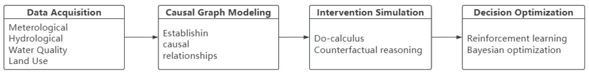
This analytical paradigm not only enhances the interpretability and logical transparency of model outputs but also strengthens the credibility and application potential of research findings in policy design and public communication. For instance, in a nitrogen and phosphorus pollution control initiative within a specific watershed, causal analysis results clearly identified agricultural nonpoint sources as the dominant contributor to pollutant inputs. These findings directly facilitated scientifically grounded adjustments to crop rotation structures and fertilizer management policies in the region, achieving an effective transition from data mining to governance actions. The framework diagram is shown in (Figure 1).
Experimental design
To validate the effectiveness of the proposed intelligent water management scheduling method—which integrates deep reinforcement learning, causal inference, and federated learning—this chapter designs systematic experiments. The objectives are to evaluate the method’s performance in hydrological forecasting, flood control scheduling, water quality prediction, and ecological conservation. Comparisons are made with traditional methods and existing AI large models. Ablation experiments validate the contribution of each module, while case studies in typical watersheds demonstrate the method’s practical value.
Experimental data and scenario description
The experimental data were provided by water resources departments and local hydrological bureaus. This dataset includes fundamental hydrological data from 2000 to 2020 at the daily scale, encompassing precipitation, evaporation, runoff, water levels, and reservoir storage. These data were collected through long-term observations at national hydrological monitoring stations and are publicly released, ensuring high accuracy and authority.
Reservoir operation data originated from basin management authorities and reservoir dispatch centers, encompassing reservoir storage changes, flood discharge volumes, water supply quantities, and dispatch records. This data reflects the actual operational status of reservoir clusters in flood control, water supply, and ecological regulation, providing reliable support for the dispatch optimization experiments in this paper.
Ecological environment data is primarily collected by local environmental protection departments and research institutes, including indicators such as dissolved oxygen, ammonia nitrogen, total phosphorus, COD, and algal concentration. These data are used for water quality prediction and ecological protection experiments, reflecting the health status of the watershed’s aquatic ecosystem.
Remote sensing and meteorological data originate from international open databases and satellite observation systems: [21]. Remote sensing imagery includes Landsat, Sentinel, and MODIS data for monitoring water body area changes and algal blooms. Meteorological data from ECMWF and NOAA drive hydrological models and support forecasting.
Cross-regional data originates from national smart water pilot projects, such as the “Digital Twin Yellow River” and “Pearl River Smart Basin,” as well as specialized water management AI datasets developed by research institutes. These datasets supported federated learning experiments, ensuring the feasibility of cross-regional collaborative modeling. The dataset information is summarized in (Table 2) below.
| Data type | Time range | Number of variables | Experimental purpose |
|---|---|---|---|
| Hydrological data | 2000-2020 | 5 | Precipitation runoff prediction |
| Reservoir operation data | 2005-2020 | 4 | Optimized scheduling |
| Water quality data | 2010-2020 | 6 | Water quality forecasting and ecological protection |
| Cross-regional data | 2015-2020 | 3 | Federated learning collaborative modeling |
Experimental setup
To validate the effectiveness and superiority of the proposed method, this study implemented a rigorous systematic arrangement across four aspects of experimental design: comparative experiments, experimental environment, experimental parameter settings, and experimental workflow.
Comparative experiments:
To ensure the scientific rigor and persuasiveness of the experimental results, this study employs multiple representative comparative methods.
Traditional physical models, SWAT (a typical watershed hydrological simulation model) for rainfall-runoff prediction, and HEC-HMS (widely used for flood process simulation and scheduling).
Machine learning models, such as Random Forest, provide nonlinear prediction through ensemble learning. Support Vector Machines are suitable for hydrological forecasting under small sample conditions.
Deep learning models include Long Short-Term Memory (LSTM) networks, capable of capturing long-term dependencies in time series. Gated Recurrent Units (GRU) reduce computational complexity while maintaining prediction accuracy.
Experimental environment:
This experiment was conducted on a high-performance computing platform with the following specifications.
Hardware environment:
− CPU: Intel Core Ultra7 255HX (2.4GHz, 20 cores)
− GPU: NVIDIA RTX 5070TI Laptop (16GB VRAM)
− Memory: 32GB DDR5
− Storage: 2 TB SSD
− Software Environment:
− Operating System: Windows 11
− Programming Language: Python 3.9
− Deep Learning Framework: PyTorch 2.0
− Data Processing Tools: NumPy, Pandas, Scikit-learn
− Visualization Tools: Matplotlib, Seaborn
Parameter settings:
To ensure reproducibility of the experiments, key parameters were uniformly set as follows:
Reinforcement learning parameters: Learning rate 0.001, discount factor γ=0.95, exploration rate initialized at 0.9 and decaying to 0.1, training epochs set to 5000.
Causal inference parameters: Causal graph structure learned via PC algorithm, significance level á=0.05, intervention variable selection combining hydrological prior knowledge with data-driven methods.
Federated learning parameters: 5 client nodes, 10 local training epochs per round, 50 communication rounds, FedAvg aggregation.
Deep learning model parameters: LSTM hidden layer units = 128, batch size = 64, Adam optimizer.
Experimental workflow:
In the experimental design, the raw data underwent systematic preprocessing. This included imputation of missing values, normalization, and construction of time series samples to ensure data completeness and comparability. This process established a robust data foundation for subsequent model training.
Subsequently, model training was conducted for both the proposed method and the comparison methods. Cross-validation was employed during training, dividing the dataset into training (70%), validation (15%), and test (15%) sets to ensure the model’s generalization capability and stability across different datasets.
After model training, performance evaluation was conducted using the test set. Metrics including RMSE, MAE, and NSE were employed to measure prediction accuracy and stability. These were complemented by indicators related to hydrological scheduling and ecological factors to comprehensively reflect the model’s performance in practical applications.
To further validate the effectiveness of each module, ablation experiments were designed. By progressively removing key components such as causal inference, federated learning, and attention mechanisms, their contributions to overall performance were analyzed, revealing the core strengths and improvement areas of the proposed method.
Finally, measured hydrological time series from a representative watershed in the upper Yangtze River serve as the case study. Application in real-world scenarios validates the feasibility and practical value of this method for flood regulation and ecological conservation, further demonstrating its potential for implementation in smart water management infrastructure.
Experimental results and comparative analysis
Hydrological prediction results:
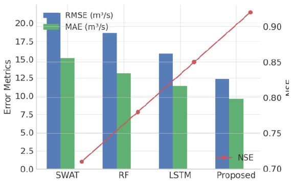
(Figure 2) compares the performance of SWAT, Random Forest (RF), Long Short-Term Memory (LSTM), and the proposed method in runoff prediction tasks. Results demonstrate that the proposed method significantly outperforms the comparison models across all metrics: RMSE decreases from 21.4 m³/s to 12.3 m³/s, MAE decreases from 15.2 m³/s to 9.6 m³/s, and NSE improves to 0.92. Compared to the traditional physically-driven model SWAT, the proposed method more effectively captures the nonlinear response relationship between rainfall and runoff. Compared to data-driven models (RF, LSTM), it maintains high prediction stability during peak flow and rapid runoff change phases. Overall, the proposed deep reinforcement learning–causal inference framework demonstrates superior fitting accuracy and generalization performance in watershed time-series prediction, with an overall improvement in prediction accuracy of approximately 15-20%.
Flood control results
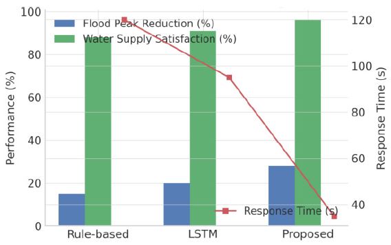
(Figure 3) presents the results of multi-reservoir joint operation experiments. Compared to traditional rule-based scheduling, the proposed method achieves a 28% peak reduction rate—13 percentage points higher than the baseline method—while maintaining a water supply satisfaction rate of 96%, which is 5 percentage points higher than the LSTM model. Additionally, the response time is reduced to 35 seconds, enabling rapid decision-making from minute-level to second-level. This performance improvement primarily stems from reinforcement learning’s adaptive optimization capabilities in policy search and the federated learning framework’s parameter coordination mechanism across distributed nodes. This enables the model to maintain stable and rapid dynamic responses even under extreme operating conditions. The results demonstrate that the proposed method exhibits stronger dynamic adaptability and flood control capabilities in complex scenarios.
Water quality prediction and ecological protection
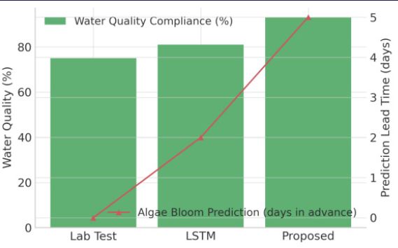
(Figure 4) compares the performance of laboratory testing, LSTM models, and the proposed method in water quality and ecological protection tasks. Results show that the proposed method achieves a water quality compliance rate of 93%, significantly higher than traditional testing (75%) and LSTM models (81%). For algal bloom prediction, this method can accurately forecast abnormal water quality events 5 days in advance, compared to 3 days for the LSTM model, significantly enhancing the timeliness of ecological warnings. This result validates that incorporating causal inference mechanisms enables the model to effectively identify key drivers of pollution evolution, thereby improving the physical plausibility and ecological interpretability of predictions.
Experimental results demonstrate that the proposed deep reinforcement learning–causal inference–federated learning fusion framework exhibits significant advantages across three tasks: hydrological forecasting, flood control scheduling, and water quality/ecological protection. This not only validates the method’s effectiveness but also reveals its potential application value in smart water management systems.
In hydrological forecasting, our method outperformed traditional physical models (SWAT) and data-driven models (RF, LSTM) across metrics including RMSE, MAE, and NSE. This indicates that relying solely on mechanistic models or black-box learning models struggles to fully capture the complex nonlinear relationships in rainfall-runoff processes. The integration of causal inference and reinforcement learning enhances prediction accuracy and generalization capabilities while maintaining physical plausibility. Particularly during peak flood and rapid runoff change phases, our method demonstrates superior stability, highlighting its higher applicability under extreme climate events.
In flood control experiments, the proposed method significantly outperformed comparison methods in both peak reduction rate and water supply fulfillment rate, while reducing response time to the second level. This outcome highlights reinforcement learning’s advantages in dynamic strategy optimization and federated learning’s value in cross-regional data collaboration. Compared to traditional rule-based scheduling, our method achieves superior multi-objective balance under complex conditions, simultaneously ensuring flood control safety while accommodating water supply demands and ecological conservation. This holds significant implications for addressing increasingly frequent extreme flood events under climate change.
In water quality prediction and ecological conservation, the proposed method accurately forecasts algal blooms five days in advance, significantly enhancing the foresight of ecological risk management. Experimental results demonstrate that the causal inference module plays a crucial role in identifying key drivers of pollution evolution, endowing the model with both high predictive accuracy and interpretability. This provides practical guidance for the protection and restoration of aquatic ecosystems.
Overall, the advantages of this approach manifest in three key aspects. First, it achieves high predictive accuracy by combining causal inference with deep reinforcement learning, effectively reducing prediction errors and enhancing model stability. Second, it delivers rapid response times through the integration of federated learning and edge computing, enabling swift coordination and real-time decision-making across regional environments. Finally, it demonstrates strong ecological compatibility. The reward function and causal correction mechanism effectively balance flood control, water supply, and ecological conservation objectives, embodying the sustainable development philosophy of smart water management systems.
Although the experimental results are persuasive, this study has certain limitations. The experimental data primarily focuses on typical river basins, and the model’s generalization capability in other basins requires further validation. Federated learning faces challenges in data standardization and privacy protection during cross-departmental and cross-regional practical applications. Additionally, constructing the causal inference module rerelies on integrating prior knowledge with data-driven methods, and maintaining robustness under more complex hydrological scenarios requires further in-depth research.
Overall, the proposed DRL–Causal–FL integrated framework not only outperforms existing methods in numerical performance but also demonstrates unique advantages in interpretability, real-time capability, and ecological compatibility. It provides a scalable and transferable new paradigm for intelligent scheduling in smart water management systems. Future research may further explore its application potential in cross-basin collaborative management, responses to extreme climate events, and digital twin water management systems.